Like many other industries, the water industry is currently under pressure to do more with less. One way in which water utilities can improve their operational efficiency, and therefore cut costs, is through a comprehensive, IT-based asset management system.
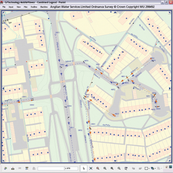
For water utilities, large and expansive water and wastewater distribution systems represent a high percentage of total corporate assets. The geospatial data (spatial software and analytical methods with terrestrial or geographic datasets) generated from these assets is essential to allow the utility’s workforce to move forward on future planning, construction and maintenance. Without an accurate database, information management can become cumbersome and resource-intensive.
With new technologies, a geospatially-powered solution enables water utilities to manage daily operations as well as long-term transactions. A comprehensive asset management system brings together the tools needed to plan expansions, conduct engineering analyses and design work orders for field personnel. It allows water utilities to integrate massive amounts of data in a consolidated form so they can better manage mapping, asset and maintenance records.
Whether a water utility serves a thousand customers or a million, it can realize measurable benefits when it leverages asset management data across all departments. An IT-based asset management system can help:
- Ensure distribution components are properly maintained
- Increase the effectiveness of future planning activities
- Better manage water distribution
- Support mobile workforce management for all types of field work
Geospatial integration in action
The San Jose Water Company in California is an industry leader in incorporating geographic information system (GIS) data into its daily operations. They serve more than one million customers and have about 350 employees.
Initially, San Jose Water incorporated GIS data for digital map creation. It now also uses an open geospatial platform to deliver data to employees and customers. “Geospatial integration has definitely boosted our productivity and there’s obviously a cost benefit associated with that,” says Jeff Hobbs, GIS coordinator for the San Jose Water Company. “We use the system as a tool to solve problems, manage our assets and improve overall management. The openness of our system allows us to easily house data in our database, as well as leverage it in a multitude of other applications like our customer information system (CIS) and more mainstream applications like Google Earth. With an information-based management system, we can easily pinpoint watermain leaks and determine which watermains need to be replaced and rank them by priority.”
The Henry County Water and Sewerage Authority (HCWSA) in Georgia is another utility that has realized the value of an IT-based infrastructure management system. The utility historically relied on paper-based maps and as-built drawings. However, because they were easily damaged or misplaced, the documents were housed at the utility’s main office with restricted access. Field crews made regular office visits to obtain maps, aerial photos and other information. This required a lot of time from office personnel to locate and copy data, as well as lots of unnecessary driving time on the part of field crews.
Like San Jose Water, HCWSA also implemented an integrated geospatial system, which has allowed the utility to digitally map its infrastructure. The utility also recently integrated an application that allows it to more easily push information out to the field. When a project is entered into the asset management database, all data associated with that project is captured. Field personnel can link to a sewer line in the database, for example, and pull up all the information associated with that line remotely, including aerial photos.
Allen Rape, GIS manager at HCWSA, says the technology saves time both for office and field personnel. “We were able to sell our board members on the technology because we showed them that the amount of time that could be saved in person hours could be directly translated into a significant dollar value,” he says. “We literally never see our field crews anymore because they’re using their laptops in the trucks to access the same information. Procedures that used to take two to three days now take two to three minutes, literally freeing up days for us to complete additional projects and work orders.”
In Australia, the driest inhabited continent, South East Water Limited has the demanding task of supplying a steady stream of clean water to 1.36 million customers in Melbourne, the nation’s fastest-growing city. The utility has turned to integrated geospatial management as its core platform for storing and managing crucial spatial data related to the more than C$1 billion worth of assets that make up its water distribution network. The utility has also implemented the system to analyze the data for better decision-making and for distributing data to key stakeholders via the web.
Non-revenue water (NRW) is a measure of the volume of water lost, often due to aging, leaky infrastructure. Using an integrated geospatial asset management system, South East Water Limited has been able to achieve one of the lowest NRW levels in the industry. “Maps, more than any other invented metaphor, can inspire inference of information and quickly communicate knowledge,” says Martin Dunkley, manager of asset information at South East Water Limited. “The large majority of the information handled by a utility has a ‘place in space,’ so logically the core platform should be geospatially based.”
Sharing is essential
Forward-thinking companies such as San Jose Water, Henry County Water and Sewerage and South East Water Limited understand the benefits of a comprehensive, geospatially-powered water infrastructure management solution.
Improved water management is essential as we replace aging and crumbling infrastructure. As other water utilities are challenged by increasing water demands under the current economic conditions, we expect to see more providers turn to similar spatially-enabled asset management systems. WC
Tony DiMarco is the director and global industry manager for utilities and communications business at Intergraph Corporation.


[…] This post was mentioned on Twitter by Canadian Water, WaterTrax. WaterTrax said: The water industry is currently under pressure to do more with less, check out these way to cut costs http://ow.ly/28L8h […]